Drone Mapping & Photogrammetry
Asset Inspections & Site Documentation
Vantage Drone Services provides aerial mapping and documentation solutions for construction sites, real estate properties, industrial assets, and land management projects. Using advanced drone technology and photogrammetry, we deliver high-resolution maps, 3D models, and detailed inspection reports—helping you save time, reduce risk, and make informed decisions.

01
Site Assessment & Planning
We start with a detailed site assessment to understand your objectives, terrain, and the assets that matter most — whether that's the whole property or a specific roof, structure, or piece of equipment. We plan the flight path and define the inspection scope up front.
02
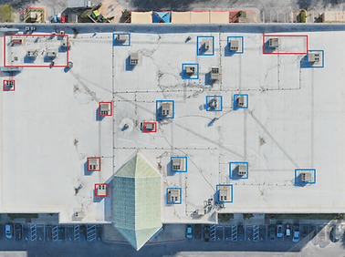
Aerial Data Capture
Using high-resolution drones equipped with RTK/PPK GPS, we capture precise aerial imagery, video, and close-range asset detail in the same flight program — mapping and inspection-grade imagery gathered together instead of two separate visits.


03
Data Processing & Modeling
Imagery is processed using advanced photogrammetry software into 3D models, orthomosaics, and volumetric measurements, alongside a visual condition review with areas of concern clearly marked.
04
Deliverables & Actionable Insights
You receive one structured package: high-resolution maps, 3D models, and an annotated inspection report — in formats that support both project planning and maintenance/compliance records.